The Team
Dan Holz – Manages the flagship Seattle REI climbing department, very experienced climber and all-around adventurer. Summited Rainier via Ingraham Glacier (and D.C.?)
Hooman Aprin – Another REI cohort – runs the climbing pinnacle at the Seattle REI. Former Exum guide, Guided on Everest, in the Himalayas, first ascents in AK, and all over the world. Summitted Rainier via Ingraham and Emmons Glacier routes, probably more
Jared Carlson – if you’re reading this, you probably already know me. If not, I run around on glaciers in Juneau, AK making sure cruise ship passengers don’t fall into crevasses. I commute to work in a helicopter. Never set foot on Mt. Rainier before
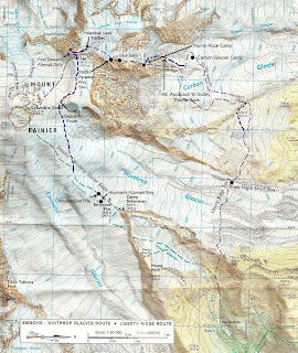
(Click on image for full size map)
Route Description from "Mount Rainier – A Climbing Guide", by Mike Gauthier, lead climbing Ranger for Mt Rainier National Park
"Featured in Fifty Classic Climbs of North America (by Steve Roper and Allen Steck), Liberty Ridge is truly the celebrated mountaineering classic of Rainier. The 5,500 foot ridge splits the steep north faces of Willis Wall and Liberty Wall, providing moderately difficult and protected climbing to the summit. This committing climb can only be accessed by crossing the jumbled ice and crevasses of the 900 foot deep Carbon Glacier.
The exposed ridge challenges climbers with moderate to steep ice climbing and a perched bivy at Thumb Rock. Willis and Liberty Walls are the backdrops that provide a constant showcase of ice avalanches and rockfall from the summit ice cap. Since the climb is so long and committing, climbers must plan their trip well, usually needing to carry their gear to the summit and descend another route.
Elevation Gain – 9,700 feet from White River Campground to Liberty Cap
What To Expect – Rockfall and Icefall hazard; 55-degree ice slopes; Glacier Travel; Grade III or IV
Time – 2 to 4 days; most parties need 2 days to reach the Thumb Rock high camp (10,760); 5 to 10 hours from high camp to Liberty Cap. Carry Over to Emmons Glacier for descent
Season – May to mid-July
First Ascent – Ome Daiber, Arnie Campbell, and Jim Borrow; Sept 30, 1935
Intermediate Camp – Lower Winthrop Glacier (7,200 feet), lower Curtis Ridge (7,200 feet) or Carbon Glacier (7,200 - 8,500 feet)
High Camp – Thumb Rock (10,760 feet)
Liberty Ridge can be gained on the Willis Wall side (east) or the Liberty Wall side (west). Climb the west side of the ridge crest ascending moderate snow and scree slopes (30-40 degrees) to Thumb Rock (10,760 feet), a large gendarme composed of questionable rock. The saddle just on the uphill side of this rock formation provides an excellent high camp. The area is small, however, and can be crowded on busy weekends. Also note that falling rock from Thumb Rock is possible.
From Thumb Rock, choose on of three short variations to gain the ridge above the rock face behind camp. The east face variation on the Willis Wall side is a moderate snow slope staying close to the rock. It gains the ridge 400 feet above the camp and is exposed. The right center gully is the steepest variation, having a 15 foot ice pitch (70-80 degrees) in a narrow gully that runs out onto the ridge directly above the rock. The west face variation on the Liberty Wall side is also a moderate snow slope with exposure.
Once the ridge crest is regained, ascend 40 to 50 degree snow and ice slopes to the base of the Black Pyramid at 12,400 feet. Then traverse towards Willis Wall and climb the open face. This is the steepest part of the climb, sometimes 55 degrees. It runs for three or four rope lengths, and can be hard and icy, particularly near the top of the Black Pyramid. Climb to the crest of the ridge above the Black Pyramid, where the slope angle decreases and the route joins the Liberty Cap Glacier at 13,000 feet.
From there, ascend moderately steep glaciated slopes toward the bergschrund directly above. Depending on the year and season, the bergschrund may require a short section (10 to 40 feet) of vertical ice climbing to surmount, or it may simply involve end-running the obstacle. Above the bergschrund, the rout continues on the glacier for the last few hundred feet of elevation gain to Liberty Cap.
Descent – Carry over and descend the Emmons/Winthrop Glaciers route to Camp Shurman."

No comments:
Post a Comment